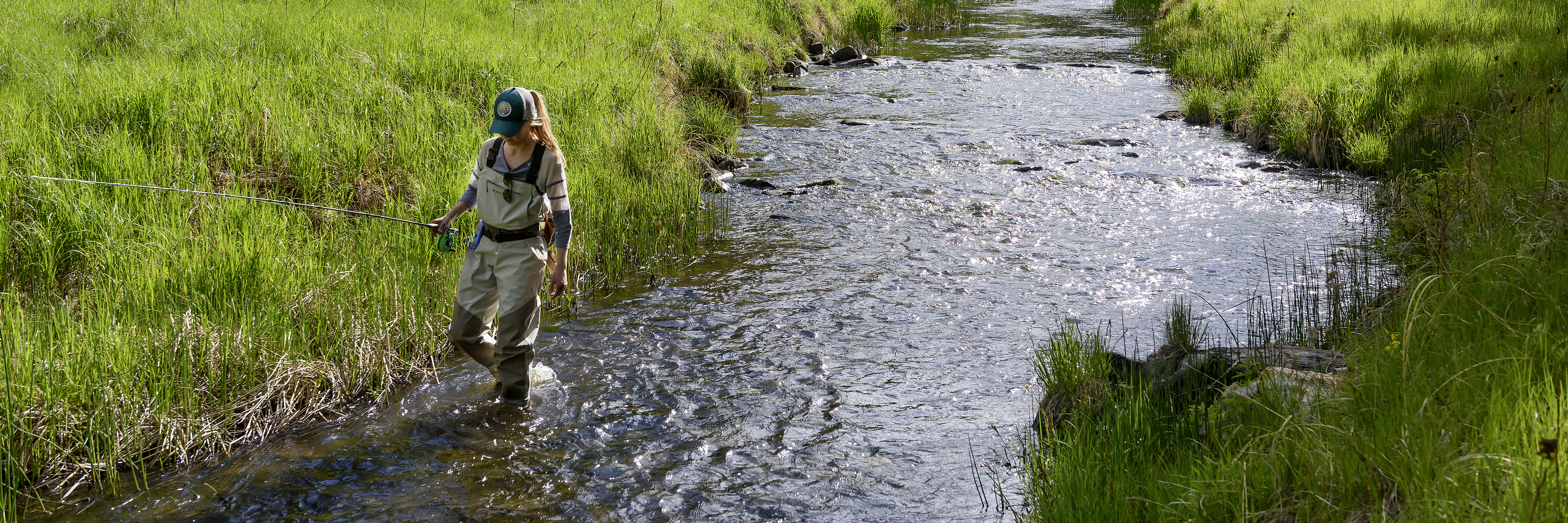
Lake Oahe Boat Ramps
Lake Oahe boat ramp information is updated as conditions change.
Ramps that are in service have approximately three feet or more of water above the bottom ramp elevation. Boaters should always use their own judgment when deciding to launch from any ramp.
For conditions of other ramps, please contact the local Game, Fish and Parks office.
water above the ramp?
Subtract the bottom ramp elevation - found in the grid below- from the current water level of Lake Oahe (type in OAHE) - found on the U.S. Army Corps of Engineer website.
| Ramp Name | Location | Managed by | Park Entrance License Required | Bottom Ramp Elevation | Condition |
|---|---|---|---|---|---|
| Bob's Landing | 16 miles W of Gettysburg off Hwy 212 | GFP | Yes | 1566.7 | Ramp is open with dock in place |
| Bush's Landing | 32 miles NW of Pierre off Hwy 1804 | GFP | Yes | 1565.7 | Ramp is open |
| Chantier Creek | 15 miles NW of Oahe Dam on SD 1806 | GFP | No | 1573.9 | Ramp is open with one dock and 1 launching lane |
| Cow Creek | 15 miles NW of Pierre off Hwy 1804 | GFP | Yes | 1567.5 | Ramp is open with one dock and 2 launching lanes |
| Dodge Draw | 27 miles NW of Gettysburg off Hwy 83 | GFP | No | 1581.0 | Ramp is open with dock in place |
| East Shore | 7 miles N of Pierre off Hwy 1804 | GFP | Yes | 1572.7 | Ramp is open with one dock and 1 launching lane, USCOE tug boat is currently on ramp but one lane open |
| East Whitlock North | 15 miles NW of Gettysburg of Hwy 1804 | GFP | Yes | 1584.0 | Ramp is open with dock in place |
| East Whitlock South | 15 miles NW of Gettysburg of Hwy 1804 | GFP | Yes | 1600.0 | Ramp is open with dock in place |
| Foster Bay | 27 miles NE of Hwy 63 & 34 intersection | GFP | No | 1604.0 | Ramp is open with one dock and 2 launching lanes |
| Indian Creek East | 2 miles SE of Mobridge off Hwy 12 | GFP | Yes | 1563.4 | Ramp is open with dock in place |
| Indian Creek West | 2 miles SE of Mobridge off Hwy 12 | GFP | Yes | 1563.4 | Ramp is open with dock in place |
| Lighthouse Point | 15 miles NW of Pierre off Hwy 1804 | GFP | Yes | 1575.0 | Ramp is open with one dock and 2 launching lanes |
| Little Bend | 41 NW of Pierre off Hwy 1804 | GFP | Yes | 1565.4 | Ramp is open with dock in place |
| Minneconjou | 45 miles NW of Pierre off Hwy 1806 | GFP | No | 1568.7 | Ramp is open with one dock and 2 launching lanes |
| Okobojo Point | 17 miles NW of Pierre off Hwy 1804 | GFP | Yes | 1607.0 | Ramp is closed |
| Peoria Flats | 14 miles NW of Pierre off Hwy 1804 | GFP | Yes | 1590.0 | Ramp is open with one dock and 2 launching lanes |
| Pike Haven | 25 miles W of Onida, off Hwy 1804 | Lease with GFP | No | 1569.7 | Open without a dock |
| Shaw Creek | 7 miles S of Pollock off Hwy 1804 | GFP | No | 1567.0 | Ramp is open with dock in place |
| South Whitlock | 14 miles west of Gettysburg off highway 212 | South Whitlock Resort | No | 1583.0 | Not in service |
| Spring Creek | 15 miles NW of Pierre off Hwy 1804 | GFP | Yes | 1562.43 | Ramp is open |
| Sutton Bay | 50 miles NW of Pierre off Hwy 1804 | GFP | No | 1573.0 | Ramp is open with dock in place |
| Swan Creek East | 9 miles W of Akaska off Hwy 83 | GFP | Yes | 1594.0 | Open, waiting to put dock in |
| Swan Creek West | 9 miles W of Akaska off Hwy 83 | GFP | Yes | 1573.0 | Ramp is open with dock in place |
| Thomas Bay | 12 miles SW of Selby off Hwy 1804 | GFP | No | 1590.0 | Ramp is open |
| Walth Bay | 15 miles SW of Selby off Hwy 1804 | GFP | Yes | 1564.16 | Ramp is open with dock in place |
| West Pollock | 2 miles W of Pollock off Hwy 1804 | GFP | Yes | 1573.0 | Ramp is open with dock in place |
| West Shore | 9 miles NW of Pierre off Hwy 1806 | GFP | Yes | 1567.1 | Ramp is open with 2 docks and 4 launching lanes |
| West Whitlock | 18 miles NW of Gettysburg off Hwy 1804 | GFP | Yes | 1567.3 | Ramp is open with dock in place |
